Consumers refer to properties using an address but when buying and selling, what changes hands is called a parcel. Counties record parcel transfers to protect owners’ real property rights. Parcels pre-date the postal system. Record keeping is performed at the parcel level because it is possible to sell real estate that does not have a postal address. An example would be a deeded parking space that accompanies the second-floor flat. Two parcels are part of the offer, but the consumer associates the flat and parking part with the address.
Local governments use parcel identifiers to record deeds, process liens and issue tax assessments. The format of parcel identifiers varies by location and identical identifiers can be used in multiple locations. Searching across locations with a parcel identifier is challenging because the identifiers are not guaranteed to be unique. This results in the user needing to select the parcel they are interested in from a list of parcels with the same identifier. Computer-to-computer systems that move information through business processes are not well-suited for conversations like this. Earlier real estate computer systems made partial copies of records across systems because all business was being conducted locally and computer-to-computer communications were not reliable.
A combination of the identifier and location can be used to uniquely identify a specific parcel, preserving the historical accuracy of information and streamlining information sharing across industries. The technical term for this is a compound key, a well-known and widely implemented approach to similar situations.
Parcel identifiers can be called by different names depending on the area of the country being searched. Most of the US record keeping is conducted at the county level, but I will cover that topic a little later in this article. The identifier name is part of the professional vocabulary of the area and reflects historical record-keeping practices.
- APN – Assessor Parcel Number
- AIN – Assessor Identification Number
- ASMT – Assessment
- Fee – Fee Number
- PAN – Property Account Number
- PID – Parcel Identifier
- PIN – Property Identification Number
- SBL – Section-Block-Lot Number
- Sidwell – Sidwell Number
- TAN – Tax Account Number
The format of these identifiers varies as presented in the following table.

The spaces, dashes and periods are important to preserve. Trying to decipher the identifier can be a daunting task given there are over 3,000 counties in the US. The identifier should be handled as a single (and opaque) string in software. If you simply remove punctuation, it is difficult to discriminate between 0011-01 and 001-101.
Identifiers are typically issued at the county level. Some cities (or towns) manage their parcels separately which can result in the same identifier being used for different properties located in the same county. The US Census Bureau breaks down counties into legal geographies called County Subdivisions (or sub-counties) which are townships and cities. Here is an example of Census Bureau County Subdivision information for an address taken from the census geocoder :
Address: XXX Adele Lane in Bronxville, NY 10708
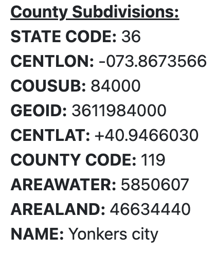
The following information is taken from the search results:
State: 36 (New York)
County: 119 (Westchester)
Sub-county (COUSUB): 84000 (Yonkers)
GEOID: 3611984000
Although the address is in Bronxville, the Sub-county is Yonkers, not Westchester. The State and County numbers are called FIPS codes used by many government data sources. The GEOID is a combination of State, County and Sub-county identifiers. Using a GEOID location with the identifier guarantees that it will be unique. It does not mean that the local government issued the identifier, but it does guarantee that the GEOID/identifier pair is unique.
Jargon is important to any conversation, so I will define some terms now for clarity. A good term for GEOID is Subcountry (not to be confused with “Sub-county”) because many other countries (including Canada) maintain location identifiers similar to GEOID. In Germany and other countries in Europe, the NUTS-3 number would be the GEOID equivalent. There are many identifiers in computer systems so we will call ours Parcel. The combination of Subcountry and Parcel is unique across the US and adding an ISO 3166 country code creates an international identification system.
Country: US – International Standard
Subcountry: 3611984000 – Legal geography within a country
Parcel: “5-5248-603-0” – An identifier used within a legal geography
Unique Identifier – “US” + “3611984000” + “5-5248-603-0”
Here is another example that demonstrates the approach in use with a more complex Parcel in Pennsylvania:
Unique Identifier – “US” + “4204949548” + “14 032 051.0 229.00a”
If you wanted to pull the key apart and use pieces of the compound key (“only show me addresses in Canada”), it should be created with a separator. Common separators are periods, commas and dashes. Unfortunately, the Parcel can contain these characters foiling the scheme. We can either a) store and pass multiple fields or b) consider using a single field URN as documented in IETF RFC 2841. The Universal Property Identifier workgroup of RESO is working on these issues to make cross-system referencing easier.
Mapping a compound key to an address allows consumers to drive the process with familiar addresses and the systems behind the experience to communicate efficiently.
Leave a Reply